Print Viewport
This option will print the selected Viewport to any of the available Windows printers on the PC or network. The user has the
option to select the Viewport to print and can also optionally print a Grid and a Plan Form.
The printout can also be directed to a PDF or DXF file if required, select the output as ‘Autocad DXF file’ instead of
‘Printer/Plotter’. The user can then choose the output DXF filename, the style of the polylines (contours) and
whether to output 2d or 3d data.
Viewport
Select a Viewport from the dropdown list
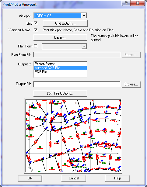
Grid
Tick this box if you want a grid and then press the button to set the Grid parameters such as the grid line spacing etc.
For more information click here
Viewport Name
Tick this box to print the viewport Name, Scale and rotation in the bottom left corner of the sheet.
Layers
The layers button allows any layers to be made visible or invisible.
This allows you to control which layers will or will not be printed.
To ensure a layer is printed, check the visibility box, labelled 'Vis'.
To ensure a layer is not printed, uncheck the visibility box.
Plan Form
The Print menu option allows the user to select a plan form to be printed with a viewport.
A Plan Form contains the lines and text which form the border and explanatory text on a plan.
There are two different types of Plan Forms, one stored in the GeoSurvey_config.xml file and others stored in standard .acs jobs.
XML Plan Form - Preferred
XML Plan forms - for more information click here
GeoSurvey (ACS) Plan forms - for more information click here
Plan Form Name
If you want to use a GeoSurvey .acs file as a plan form, enter the name of the file here
Output To
Select the destination for the plan: Printer, DXF file or FDF file
File
If writing to a DXF file or PDF file, this field will be enabled and you can select the name and folder for the output file.
DXF File Options
Press this button to set the line type for polylines and whetehr to write 2d or 3d values.
For more information click here